Grid references
Although it is still important for all of us to focus on the protected areas in our 100km region, we are introducing an extra angle to the challenge for 2003.
We would like to expand the collection of information to other regions and work towards an online atlas system for all the serious birders to benefit from.
The new listing program make provision for this by allowing the observer to enter the atlas grid for each list submitted, and to add additional information for the area. If you are not sure of the grid reference, rather leave it blank and give a good description of where the area is.
The observer also have the capability to expand the bird list to a national list for the hole of Southern Africa. This will allow all observers to submit list from other destination that they travel to.
The grid reference that will apply works on the same basis as the reference used during the atlas project. We hope to include a mapping system to the listing program in the near future to ensure the accuracy of the grid references submitted.
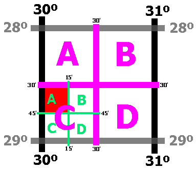
Here is some indication on how to determine
the grid reference to use:
Each degree square is designated by a 4-figure number made up
of the values of the Latitude and Longitude (in that order) at
its NW corner.
Each degree square is divided into four 30' x 30' squares.
These are lettered A
B C D as indicated in the sketch.
Each 30' x 30' square is sub-divided into four 15' x 15' grids.
These are lettered A
B C D as indicated in the sketch.
In the sketch, the red area indicates the coverage of the quarter degree
grid 2830CA.
This is the maximum size grid reference that should be used. It
is also the same area as one 1:50000 scale map.
We would prefer an ever more refined reference where each 15'
x 15' square is divided into 9 block of 5' x 5' and these will
be indicated by an additional 1 to 9 added at the end of the reference.
2830CB3
as indicated by the blue area in the sketch.